Friday, November 11, 2022

My Epic Journey to Everest BC Part 4: Namche - Deboche - Dingboche


Every mountain top is within reach if you just keep climbing


DAY -8

14 October 2022 Friday, Namche to Tengboche (3,860m) to Deboche (3,820m) 

We hiked 12.5 km, 8 hours with a total ascent of 1,100 meters and got impacted by mild symptoms of AMS. 

Tengboche


I woke up about quite early today, maybe we had a good rest yesterday - felt very fresh to continue the journey to Tengboche. As usual, the dining room was full with hikers preparing for the day. I don’t know what to have for my breakfast, so I just choose bread and honey.  Coffee is a must! As we are having our meals, one by one hikers start leaving the teahouse for their own directions - some may prepare the acclimatization, some may head to Tengboche and other may go back to Phakding. 

Hikers

Today will be a long journey as we are starting hiking above 3,800m elevation. Less oxygen and high altitude. We need to be extra careful to avoid AMS symptoms. Once everyone is ready we start our trail out from Namche. For about 10 - 15 minutes, we are using the same route like yesterday to Namche until we make a right turn with a slope down along the side of mountains. I noticed quite a lot of people on the trail heading to Tengboche. I can see clearly in front of me is Mount Everest (most of the time hiding behind another mountain), Mount Lotshe (on the right of mount Everest) and Ama Dablam, mostly on the right side of your trail. Really stunning view. 

Amazing trail

After nearly 2 hours of hiking, we had our coffee break at a village called Ama Dablam with the view of Ama Dablam. We are waiting for another person who has a problem with knee injury. We rested for 20 minutes and then continued our hiking until we reached Phunklu Thanga where we had our lunch there - Dhal Bhat. 

Dhal Bhat

From Phunklu Thanga, we need to cross another suspension bridge to cross the river. We saw the helicopter perform the rescue. We learned that there was a hiker who had an accident and broken leg. We knew that we needed to be really careful in this expedition because we are in a remote area and it is not easy to get any help if required. After crossing the suspension bridge, for the next 3 - 3.5 hours the trail shot straight up until we reached Tengboche. This is one of the toughest hikes - do not worry about how far the distance is, just one step at the time until we reach there. We reached there around 3.30 p.m.

Ama Dablam rest area

Tengboche is just a small mountain village at 3,860 meters and this is the largest monastery in the area. From Tengboche we can see the panoramic views of the mountainscape of Himalayas - Everest, Lhotse, Nuptse (7,861m), Tawache (6,495m), Ama Dablam (6,170m) and Thamserku (6,608m) in just a view.  We spent around 20 minutes enjoying the amazing 360 degree mountain peak views and felt so relaxed that we almost completed our journey today. I think this is my favorite trek between Namche to Tengboche - nice spectacular walking in the forest, amazing view of the mountain peaks, nice teahouses and nice weather (acceptable cold). 

Struggle - knee pain

We learned from our guide that we need to continue to a small village called Deboche overnight. From Tengboche we descended slowly in quite a thick forest before reaching Deboche for about 30 - 40 minutes. We met Naomi - the Japanese lady hiker who planned to hike to EBC and Three Passes alone, unfortunately she was unable to get the room in this Teahouse and went back to Tengboche to find her room for tonight. If not mistaken, the first time we met her was at Paiya village. We stayed overnight at Paradise Lodge & Restaurant Deboche. 

Paradise Lodge Deboche

I think the altitude has impacted me - I felt dizziness, headache and fever. I went to the dining room and there was a nice heater in the center of the room. I sat near the heater while waiting for my dinner. Really make me warms, that helps a bit for my body to recover. Maybe this is my lucky day, I can still WhatsApp my doctor, Dr Yusni Mohd Yasin, UNI Clinic - seek his medical advice on my situation. I took some medicine as prescribed (also provided by him before the expedition) and went inside my sleeping bag. It was really hard to breathe, I woke up every hour of the night - really a long cold night for me.  


DAY -9

15 October 2022 Saturday, Tengboche (Deboche - 3,820m) to Dingboche (4,410m)

11.6 km hiking for 7 hours with total ascent of 1,600 meter, cross the mark of 4,000 meters altitude and acclimation hike to 4,348 meters

Recite prayer

I felt much better this morning compared to last night - no more headache but my breathing still not good and felt like no oxygen went to my tired muscles. Unfortunately, we don’t have much time to spare, we lost 4 days because we were stranded in Phaplu and a new starting point for hiking at Kharikhola instead of Lukla. On top of the original plan from Lukla, our additional two days was equal to 35 km in hiking  and more than 3,000m in elevation. 

Tomorrow we needed to skip a day for the acclimation at Dingboche to make up for time.  Our plan was to acclimatize while hiking slowly and once we reached Dingboche, we will do an acclimation hike - as long as it is higher than our sleep altitude, i guess it should be fine. 

So amazing

We saw a lot of white monastery statues along the hiking trails. After a while, I noticed that there were not many green trees around us, I guess we had crossed 4,000 meters in altitude. We have crossed the tree line and expect less oxygen - heavy breathing. We need to stay calm and think positive - physiology to avoid AMS.  Like our guide keeps reminding - this is your epic holiday, enjoy the scenery and don’t push yourself. Just enjoy!

4,081 meters altitude

We break for lunch at Annapurna Fast Food Kitchen 4,081m (according to Garmin) - if not mistaken the place called Pangboche. As usual, Dhal Bhat or Maggi are our choices, but yet the taste is getting tasteless - just for carbo loading. I do not really take much for lunch as I looked beside the Teahouse is a small dusty hill that we need to climb after lunch. At 4,000 meters altitude, every step is really hard and every deep breath to feel the oxygen going into your lungs. The sunshine was really bright in the cold temperature - we walked on a fine dusty trail like a desert with a 360 degree view of mountains.  The panorama view of majestic and magical mountains captured my mind. I knew that I missed it soon.   

Crossing the tree line

I can feel that we have a lot of up and down hiking today - when I looked at my Garmin Fenix 7, I noticed that our total ascent is 1,600 meters - that is a really high climbing day.  Finally we reached Dingboche where on the right side we saw the glazier river come down - i guest from Ama Dablam or other mountains near mount Everest and on the left side were the hills that we need to climb to Loboche tomorrow. 

Yaks attack!

It was a really tiring day cause I was not well this morning but reaching here is a blessing for me. It is just another two days before we reach Everest BC. It's just another two days that I need to stay strong and keep healthy to ensure my dream comes true. I am really tired but yet tomorrow we will skip our acclimatization hike due to time not permitted. It is a bad idea!

Dingboche 

We decided to do an acclimatization hike today - as high as possible. Climb high, sleep low is the concept to avoid AMS. After checking-in, we just left our duffel bag and backpack in the room, drank a lot of water to keep me hydrated and started climbing the Nangkartshang Peak. We scale halfway at least 4,500m elevation - hope it is enough for acclimatization. Nangkartshang Peak is 5100m altitude located behind our Teahouse. 
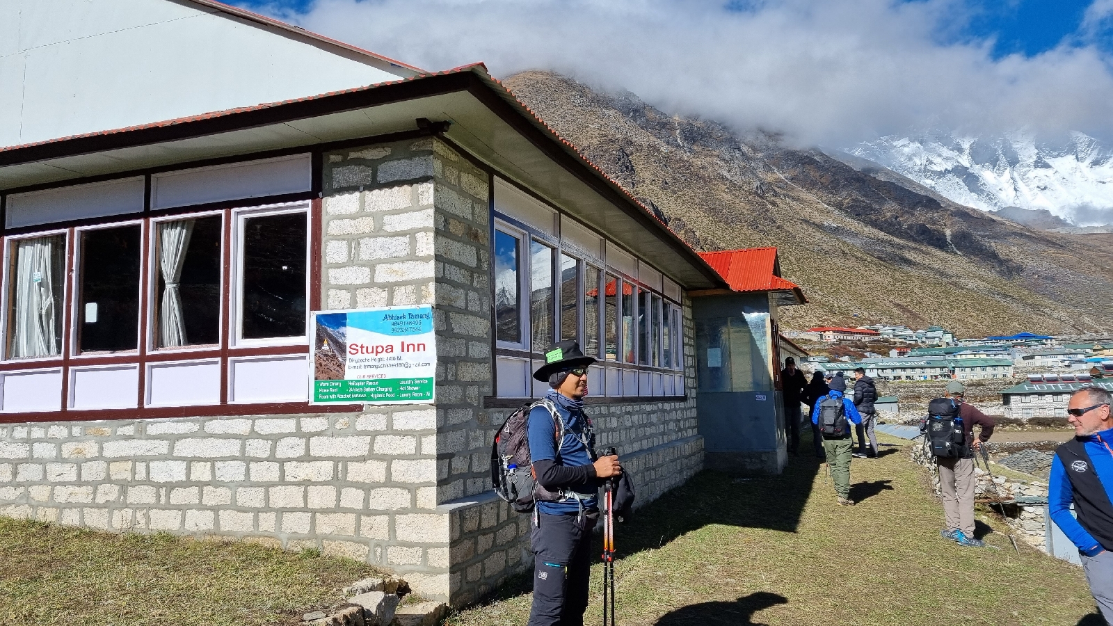
Stupa Inn Dingboche

We descended down back to our Teahouse - Stupa Inn, Dingboche 4,410 meters, we saw quite a number of Yaks eating around the area - de-tour a bit to avoid the Yaks. The view from the top of the hill is so fantastic, we cannot stay longer due to the cold weather. At that time, I  just thought a cup of hot coffee would make my day. 

Acclimation hike

As usual after dinner, we chatted for a while and the guide briefed us about tomorrow's journey to Lobuche. For the first time tomorrow, we will cross 5,000 meters altitude. Amazing experience for my Epic journey and the best part is we are far away from “the world”.


Good night.


Thursday, November 10, 2022

My Epic Journey to Everest BC Part 3: Phakding - Namche - Acclimatization

The best view comes after the hardest climb

DAY -6

12 October 2022 Wednesday, Phakding to Namche Bazaar (3.440m)

The third day hiked 14 km for 9 hours with a total ascent of 2,600 meters on another wet day and reached the biggest town in the Himalayas. 

One of the highest hill above Hillary bridge

Good morning! I am very excited today as we are heading to Namche Bazaar, the largest town in the Himalayas. Today we will have a serious climb up to Namche with a total ascent up to 2,600 meters and from altitude is 830 meters. After a nice breakfast - bread and honey, we suited up with rain gear to face another wet day. One thing about nature that we cannot really plan 100% for anything when hiking in the mountains. It is what it is right?


With Nazim

After 20 minutes hiking, we reached a checkpoint to apply for the permit for Sagarmatha National Park entry. The uphill trudge to Namche continues and numerous suspension bridges we needed crossed. I do not remember if we ever had a trail for downhill between Phakding to Namche - all mainly uphill's trails or maybe one trail down after the second check-point to Sagarmatha National Park.

Stunning view like Japanese garden

After the second checkpoint we were descending down to the river side, the rain getting heavier but we can see the famous Hillary suspension bridge on top of the mountain. Which means that we need to climb up to the entry of the bridge.  This is the final suspension bridge named after Sir Edward Hillary that crosses the Dudh Koshi River at 410 feet high before Namche Bazaar. 

Check-point for permit

I do not feel comfortable crossing it as I can feel the sways by winds but yet no other options - just look forward and walk straight. At the end of the bridge, I felt like it was swinging a bit stronger and when I looked back, there was a group of Yaks entering the bridge. You can feel the heavy movement behind you. I speed-up my step to go out of the bridge. 

Hillary suspension bridge, the highest in the world

After the Hillary bridge,  for the next 2.5 - 3 hours we got to deal with the extreme steep climb up to Namche Bazaar.  I can see a lot of people along the trail are scrambling their way up and also resting to catch their breath before continuing the zig-zag climbing through the forest and dusty trails. I only focused on my steps and heart rate, taking it easy all the way up together with my other hiking buddies.


Take a break, let the King of Road pass thru first

After steep climb, another 1 hour to Namche

Finally we reached the end of trails and after nearly 9 hours hiking we can see the landmark of Namche Bazaar. We can see a lot of houses and shops on the sloping hills and stunning views of the mountain peak around the city (sorry can’t remember the mountain’s name). It really makes us happy that finally we are here at Namche Bazaar which is supposed to be on our Day-3 in Nepal. It is what it is, we look forward to reaching Everest BC - our ultimate goal for this mission. 

Namche check-point

We settled down at Foot Rest Lounge & Lunch Place for 2 nights as tomorrow we will hike for acclimatization. Nice Teahouse in the middle of the city. Lot of shops selling mountaineering clothes, hiking equipment etc and branded products like North Face, Sherpa, etc are available around our Teahouse. We also took an opportunity to send our clothes for laundry at the Teahouse and it was a bit expensive. Next time, you better send direct to laundry services around the corner and cheaper by 50% for Teahouse rate.  

Namche Bazaar

After early dinner, we walked around the city - the weather was a bit chilly at night. I decided to go home and rest. It is interesting to see a city without any motorcycles. No pollution except the animal’s dropping here and there. The sky at night was so amazing with clear shining stars - millions of it, really make us realize how much pollution there is in our countries. 

The 'town' of Himalayas

“Night is wonderful opportunity to take rest, to forgive, to smile, to get ready for all the battles that you have to fight tomorrow” - anonymous 


DAY -7

13 October 2022 Thursday, Namche Acclimatization Day - Everest View Point (3,880m)

Finally the beautiful sunny day for acclimatization hike 5.2 km for 5 hours with a total ascent of 470 meters. Magical panorama mountains peak.  


Acclimatization day -  View point

Good morning. 

After 6 nights in the Himalayas, finally I had a good sleep - maybe I knew that we would stay here for another night. No need to worry about packing your bag everyday for the next journey. From our room’s window, we can see the beautiful mountain and today is a beautiful day. Finally we see the sun shine brightly to the mountains and the mountain peak looks like a golden peak. 

Climbing up to Namche Hills for better acclimatization

Immediately after breakfast, we were ready to start our acclimatization hike up to 470 meters from 3,440 meters to nearly 4,000 meters. I told myself once I reach 3,000 meters and above, I walk slowly and enjoy the mountain scenery around me. Even though I have the strength, I will take it easy and all this is about ensuring I do not get hit by AMS.

Stunning majestic mountains

As I hike up Namche's hill (not sure if there is another name), but the trail is really steep up and zig-zagged to the top. It was a really beautiful day with a clear blue sky. Amazing. We hike up to the Panorama Hotel and climb the peak nearby and guess what? In front of us, along the horizon the mountain’s peak of Everest, Lhotse and Ama Dablam. It is really huge even from far away - another 4 days hiking journey to see them closer. Subhanallah. 

Zoom in the mount Everest or Lhotse

For comparison purposes, we were at the peak of Mount Kinabalu 4.095 meters. the highest mountain in Malaysia and Borneo island (I think also the highest in ASEAN countries e.g. Indonesia, Philippines, Thailand and around the region).

Beautiful day, amazing 360 view and a cup of coffee

Amazing day, the sky is so magnificent blue and I took hundreds of photos. It was a blessing in this breathtaking scenery after two days stranded at Phaplu village and three days hiking in the rain to reach Namche. Nothing much to ask, just keep the weather like this until we complete our Everest BC expedition. Then we drop by at Panorama Hotel 3,910 meters and have nice hot tea and vegetable spring rolls. While having our snacks, we can see a 360 degree view of magnificent peaks- felt like a luxury mesmerizing scene, so magical. So awesome! Not everyone in this world is able to enjoy this amazing moment!  

#KoyokAdventureTeam

We spent some time enjoying the amazing and stunning views up here. Around 1 pm we started descending down back to Namche. Amazing day! We had our lunch at the Teahouse and then went out again to a nearby bakery shop. We were told that don’t miss the carrot chocolate cake in Namche - it is the best in the world! We were so lucky that the bakery shop is just opposite our Teahouse. We had our cake and coffee - I tell you it's really delicious! Don’t miss it if you are at Namche Bazaar. 

Wednesday, November 9, 2022

My Epic Journey to Everest BC Part 2: Phaplu - Kharikola - Paiya - Phakding

 Life is better in hiking boots

DAY -4

10 October 2022 Monday, Phaplu to Kharikola (2,137m) to Paiya (2,937m) 

The Off Road journey from Phaplu to Kharikola and first hiking day of 12 km to Paiya until dark with total ascent of 1,328 meters.

Off-road journey to Kharikola

We woke up at 3.00 a.m., got our duffel bags packed and waited at the lobby. Grab a hot coffee and sharp at 4.00 a.m. we start our off-road journey to Kharikola. Great, we have made some progress today. 

Short break after 3 hours journey

I wanted to take the opportunity to sleep on the way to Kharikola but yet the road was really terrible. Yeah it is off-road right! However, the stunning scenery of the mountain view is really worth it. Around  10.30 a.m, after 6 hours on the road we finally arrived at the place called Kharikola.  While waiting for our porters to arrive, we had our hot coffee and prepared ourselves for the hiking adventure. We learned that our porters are coming from Lukla in just half a day to Kharikola and take 2 days to climb up back to Lukla. 

The lower point before claim to another hills

At 12 noon we started our hiking journey to Surkey village. Around 2 pm we took a short break at Bupsa Guest House for lunch and continued our journey to Paiya village. Sometimes it rains here and there but we suit up with rain-coat. 

Kharikola


The trail was quite challenging, especially where some places got landslides and we needed to cross it. It was really scary falling down, I was freezed at a certain point at the landslide area. I was shivering not because of the cold weather but too scared of falling down because the landslide at the cliff was nearly 80 degrees. Eventually I managed to get through that area and speed-up to our final destination of the day. The daylight had gone, we were walking in the dark for the next one hour until we reached Paiya. Today we hiked 12 km for 6 hours and 1,300 m elevation.

Porters

Rainy and Foggy

We stayed at Trekker Lodge and Restaurant for the night. We had our Egg Fried Rice for dinner and a briefing for tomorrow's plan to Phakding. We took an early night off after waking up early this morning, a long off-road journey and hiking for 6.5 hours. In Paiya village, there is no mobile line and data which means no Internet. Good night!

Take a break


DAY -5

11 October 2022 Tuesday, Paiya to Surkey (2,535m) to Phakding (2,610m) 

The second day we hiked 17 km for 8.5 hours with a total ascent of 1,666 meters and we were back to the main routes. 

Trekker Lodge, Paiya

Our second day hiking started with a wet day. After nice hot coffee and Tibetan bread, we prepared ourselves for a wet day hiking. I guess the Monsoon is not over yet. The world's weather is unpredictable like last time and the monsoon should end by mid September. Anyway we have a mission to achieve -  “patah sayap bertongkat paruh”, we need to face it. No turning back. We continue our journey to Phakding - based on the original plan, we should arrive at Phakding on day-2. but we are at day-5 already. Anyway, our main objective is to reach Everest BC, then we think how to go home. There are few options in mind, but it is not the time to think about it. 

Stunning views

I can’t really remember how many suspension bridges I had to cross today. From Paiya we are hiking down to Surkey until we cross the river to the side of the mountains - there is a small helipad here. The stunning views along the trail beside the cliff and mountains are really amazing. Not to mention the number of waterfalls along the trails make for perfect scenery. After Surkey village, we started our climbing to Phakding - quite a high climb but we took it easy while enjoying the amazing view down the cliff. One part of me still feels nervous when I remembered crossing a landslide yesterday. Some naughty thoughts about what will happen if you fall down at the cliff with a few hundred meters drop. I really walked away from the cliff especially when the donkey or yak passed through. You do not want to be kicked away from their path, right?

.

We took a break for lunch around 12 noon at Khumbila Guest House, Chaurikharka village. They offered a great Dhal Bhat, I think the best Dhal Bhat for the entire journey. Really wet day today, having hot coffee really helps to boost our spirits. 

Phakding 

We passed through the junction between Phakding and Lukla, and we can see that the Lukla areas are still foggy. We believed we made a wise decision to drive to Kharikola and start hiking from there, if not, we are still waiting and god knows how much further. After a very long day hiking around 17 km and 8.5 hours, we finally arrived at Phakding around 4.30 pm. We stayed at Trekkers Lodge & Restaurant. We had dinner - Egg Fried Rice with Sambal (Thanks Faiz) and a short briefing for tomorrow's plan. 

Bakery & Coffee shop

Then we decided to have nice bread and coffee at the Bakery nearby. The best part is they provided free wifi and power charging services.  After 5 days without having a “real coffee”, this is the best place for “lepaking”. We chatted about our journey - the struggle and all the interesting things for the past 5 days of the expedition. 

Trekker Lounge, Phakding

Most importantly we are back to the main trail to Everest BC. Good night.


Kini Dalam Bahasa Melayu – Build a Resilient Life di Google Books

Kini Dalam Bahasa Melayu – BINA HIDUP PADU  di Google Books.  Alhamdulillah, satu lagi langkah penting dalam perjalanan penulis...